Workshop: Large-scale and scalable processing of airborne LiDAR for vegetation structure analysis
Dates: 11–13 March 2026
Location: SustainaLab, Amsterdam Science Park, University of Amsterdam, The Netherlands
Capacity: Limited to 15 participants
About the workshop
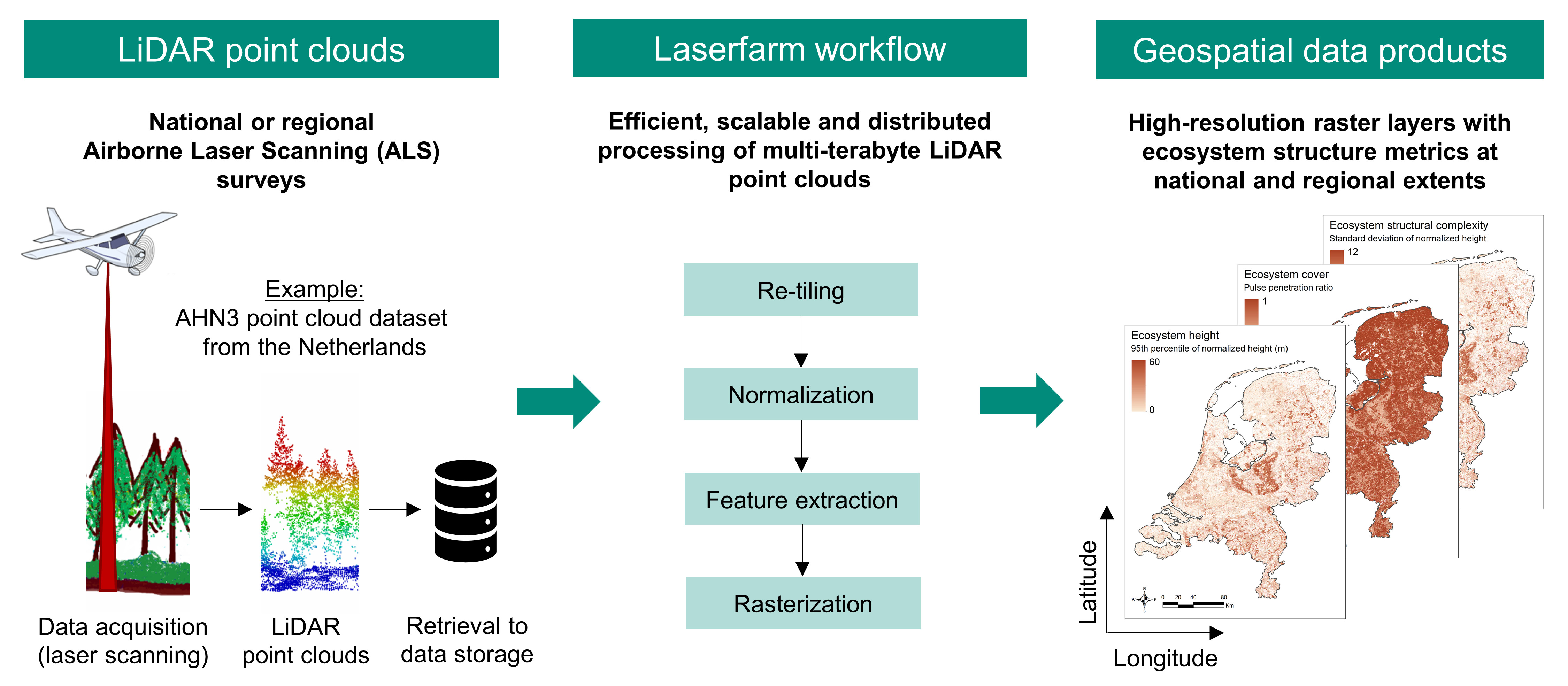
This 3-day technical training workshop focuses on the large-scale and scalable processing of airborne LiDAR for vegetation structure analysis. The workshop emphasises the implementation of scripts and workflows designed for high-throughput, scalable, reproducible, and standardised processing of LiDAR data from national and regional airborne laser scanning (ALS) surveys.
While the primary focus is on processing ALS data from national surveys, the workflows and methods presented are equally applicable to landscapes, protected areas, and nature reserves. Participants will work exclusively with free and open-source software and computational workflows.
Key themes and learning objectives
Participants will learn how to:
- Implement standardised and customizable processing pipelines for airborne LiDAR data in ecological applications
- Efficiently process large-scale ALS point clouds into vegetation structure metrics
- Apply high-throughput and scalable workflows suitable for regional and national datasets
- Use Python-based frameworks and Jupyter Notebooks for LiDAR processing
- Work with high-performance computing (HPC) systems, Google Colab, and virtual research environments (VREs)
- Ensure reproducibility and standardisation in LiDAR-derived ecosystem structure products
In addition to the hands-on technical training, the workshop will include dedicated sessions on achieving the standardised retrieval of vegetation structure metrics across Europe, using ALS data from national surveys. Together with participants, we will discuss a roadmap for metadata collection, data harmonisation, and standardised transnational processing, ultimately supporting the development of continent-wide ALS-derived ecosystem structure products.
Target audience
This workshop is designed for:
- Ecologists and remote sensing specialists with LiDAR expertise
- Research scientists and academics interested in quantifying habitat structure using airborne LiDAR
- PhD students and postdoctoral researchers working with ALS data for habitat, forest, or tree-related ecological research
- Employees from research institutions who require standardised, scalable workflows for processing airborne LiDAR data in ecological applications
Expected experience and participant profile
Participants are expected to have:
- Technical familiarity with Python
- Basic knowledge of LiDAR data processing
- A scientific background in ecology, remote sensing, earth observation, forestry or a related field
Experience with distributed or parallel computing is advantageous but not required.
Format and interaction
The face-to-face format allows in-depth knowledge exchange, hands-on problem solving, and close interaction between participants from different research backgrounds and career stages. The small group size ensures ample opportunity for discussion, individual support, and collaborative learning throughout the workshop. Participants will be working on their own laptops during the workshop, from which they will connect to the remote cloud infrastructure. Specific details of software installation and laptop requirements will be sent to elected participants before the workshop.
Registration
Participation is free of charge, but capacity is limited to 15 participants. Travel and accommodation costs will be reimbursed, but only within Europe.
Interested participants must submit a short CV and motivation, explaining how their skills, interest and work fit the workshop. Based on the submitted materials, a subset of candidates will be selected for workshop participation.
Application form:
https://docs.google.com/forms/d/e/1FAIpQLSfNVy3v6d3VUDKDOPpayU3EwPNIXDd_P3ajm0VatgEemzR4aw/viewform